“THE MOST WONDERFUL MONUMENTS OF EROSION WHICH OUR EYES HAD EVER BEHELD”: FIRST EDITION OF MACOMB’S EXPLORING EXPEDITION FROM NEW MEXICO TO COLORADO, WITH 22 BEAUTIFUL LITHOGRAPHIC PLATES AND LARGE FOLDING MAP
MACOMB, John N. and NEWBERRY, John S. Report of the Exploring Expedition From Santa Fé, New Mexico, To the Junction of the Grand and Green Rivers of the Great Colorado of the West in 1859. Washington: Government Printing Office, 1876. Quarto, contemporary three-quarter navy morocco, raised bands, marbled endpapers and edges. $6500.
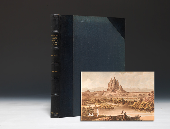
First edition of the account of Macomb and Newberry’s expedition from New Mexico to Colorado and the Grand Canyon, with 22 full page plates, including eleven chromolithographed plates, eight lithographed plates of fossils and three lithographed plates of landscapes, along with “one of the most beautiful maps ever published by the Army” (Wheat), association copy of Vannoy Hartrog Manning, a Confederate Civil War officer in the Civil War who later served as Mississippi’s Representative to the U.S. Congress (1877-83).
“In June 1859 Capt. John N. Macomb, chief topographical officer in New Mexico, was ordered to lead an expedition northward along the Old Spanish Trail in search of the desired military road into Utah. Twenty thousand dollars was appropriated for the expedition, and Macomb was authorized to take along John Strong Newberry… Macomb [and] Newberry… made their way… across the tortured landscape toward the junction of the Green and Grand rivers. At one point their view swept across a wide expanse of the country and Newberry wrote that it was ‘everywhere deeply cut by a tangled maze of canyons, and thickly set with towers, castles, and spires of the most varied and striking forms; the most wonderful monuments of erosion, which our eyes, already experienced in objects of this kind, had ever beheld” (Goetzmann, 394-7). Macomb’s geographical report was initially issued without Newberry’s geological report (because Newberry was still working for the Sanitary Commission in the west), but publication was delayed for 15 years owning to the Civil War, allowing time for Newberry’s contribution to be included. The plates depict the various canyons and rivers the expedition encountered, as well as eight geological plates. The folding map, measuring 30 by 36 inches, “is one of the most beautiful… ever published by the army. Like Ives’ maps it was done by ‘Baron’ F.W. Egloffstein… Again he speaks of the ‘Big Cañon’ of the Colorado River, thus making it clear that the term Grand Cañon had not yet emerged… This is a landmark map” (Wheat IV, 142-3). Howes M179. Wagner-Camp 379b. Graff 2647. Farquhar 23. This volume was specially bound for Vannoy Hartrog Manning, who was a Representative for Mississippi in the 45th, 46th and 47th U.S. Congresses (1877-83) after serving the Confederacy in the Civil War as Colonel of the 3rd Arkansas Infantry and 2nd Arkansas Battalion. With gilt-lettered “Van. H. Manning” printed to the spine end.
Text and plates very fresh and clean, several expertly repaired small closed tears to gutter edge of folding map, slight edge-wear, faint rubbing to boards. A scarce near-fine copy with a memorable provenance.