DESIRABLE ORIGINAL WORLD WAR II ESCAPE AND EVASION MAP, PRINTED IN FULL COLOR ON A RAYON SCARF AND COVERING GERMANY, CZECHOSLOVAKIA, HUNGARY, AND POLAND
(WORLD WAR II). Original escape and evasion map. [Great Britain: British Secret Service (MI-9)], circa 1943. Rayon scarf, measuring 36-1/2 by 32-1/2 inches, with color-printed Central European map. $2500.
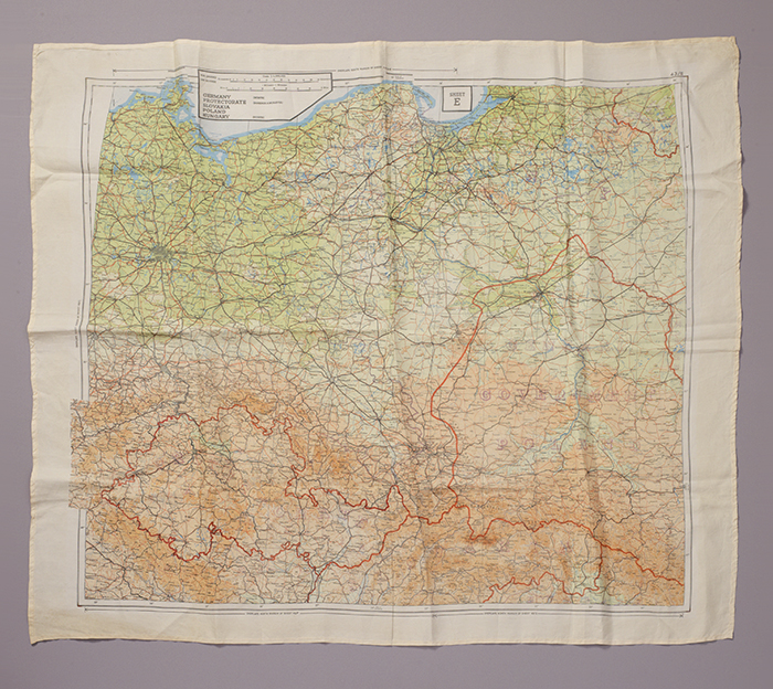
Fascinating World War II escape and evasion map covering Germany, the Protectorate, Hungary, and Poland, vibrantly color-printed on a rayon scarf.
This map, likely from Britain circa 1943, was distributed by the British Secret Service (MI-9) to facilitate the evasion and/or escape of downed Allied airmen or prisoners of war. Drawn at 1:1,000,000 scale, the map was designed to overlay other area maps. The present map is larger than the so-called "handkerchief" maps that were often sewn into clothes, but it still considered small-scale. Maps like this were a lifeline for Allied forces that ended up behind enemy lines when planes were shot down or when paratroopers were blown off course during landing. Maps such as this one were issued to lead the lost soldiers back to safety.
This example of a 43E series map shows national boundaries, cities, railroads, and basic topographical features of "Germany, Protectorate, Slovakia, Poland, and Hungary," areas corresponding to modern-day northeastern Germany, the Czech Republic, Slovakia, Poland, the tip of Hungary, and a small sliver of Russia. The map shows the post-1939 partition of Poland into a German-controlled eastern zone, a German-occupied central zone (here called "Government Poland"), and a Soviet-controlled western zone.
Numerous large cities are represented on the map, such as Berlin, Stettin (Szczecin), Danzig (Gdansk), Kongsberg, Warsaw, Poznan, Lublin, Katowice, Breslau (Wroclaw), Olomouc, Praha (Prague), Leipzig, Plzen, Dresden, and Chemnitz. The city of Oscweicim—better known today as Auschwitz—appears in the lower left quadrant of the map; there is no indication of the city's proximity to the most notorious concentration camp operated by the Third Reich.
It's estimated that Britain alone produced over 1,750,000 copies of 243 different maps depicting places all over the world. World War II-era maps were made from silk, acetate rayon, balloon cloth, and mulberry tissue paper. Rayon was the preferred material because it was light-weight, resilient, resistant to mildew, and unfolded silently. Map were smuggled in through relief packages, hidden in hollowed-out belt buckles and boot heels or layered inside or between gramophone records, gameboards (including, famously, Monopoly), and playing cards.
Slight toning to marginal edges of rayon. Very nearly fine condition.